
Anybody know how to convert KML files to GPX files? I've been downloading some fishing spots TP&W posted on they're web sight. But can only load GPX files to my Humminbird. And when I try to download the KLM, they open in Google Earth. Got any advice?
-
-
I want to say you can convert kml files to shape file in google earth and when saved as a shapefile one of the files that makes up the shape is a gpx.... it’s been a while since it’s done it.
If you can’t I may be able to figure it out in ARCmap for you -
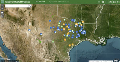
Here's a link to the TP&W page. I was hoping for the Aquilla files. Plus I've got some in Google Earth Pro that I'm not sure how to evac, from my old Garmin hand held. My HuminbirdPC software won't open Google Earth Pro either for some reason.
Comment
-
you can do it on google maps, i dont know about google earth though.Comment
-
Scroll down on this page and you can see the spots in degrees, decimal minutes and put the ones you want in manuallyComment
-
Hey thanks Kent! That might work if I can get the HumminbirdPC program to work for me. My desktop is not very compatible, or that is what my system tells me. Guess that's why it wouldn't bring up Google Earth.Originally posted by AgHntr10 View Post
The fish are biting, and there's hogs to be kilt. Gotta go!Comment
-
If you can’t get the HBird PC program to work you can just punch them in right on your unit.Comment
-
Check out GPSbabel. It can do a lot of file conversions.
It's free and very simple. I have been using it for many years!
"What is GPSBabel?
GPSBabel converts waypoints, tracks, and routes between popular GPS receivers such as Garmin or Magellan and mapping programs like Google Earth or Basecamp."Comment
-
Better than GPSBabel, don't let the website put you off, when you download, English is an option and easy to use.Last edited by XR650RRider; 04-13-2019, 08:07 PM.Comment


Comment