Morning Update from Jeff Lindner with HCFCD.
7 Day QPF
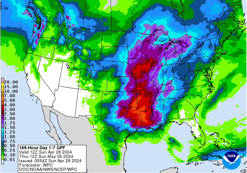
Rain chances will be increasing as moisture begins to arrive into the area from the Gulf of Mexico
Heavy rainfall will be possible Saturday-Monday
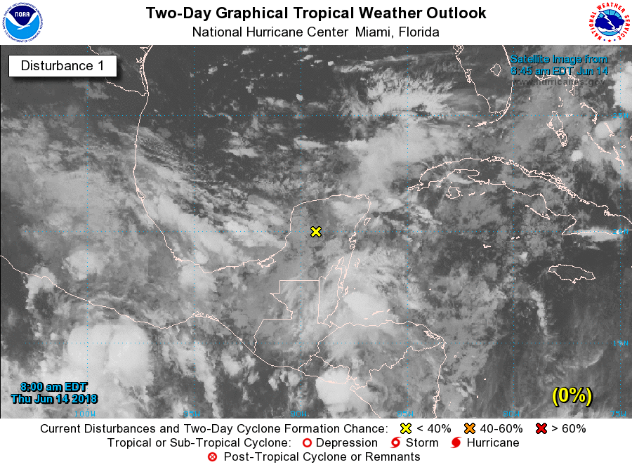
Tropical feature (91L) continues to fester in the SW Caribbean Sea with little change in organization in the last 24 hours. Surface analysis continues to show this feature as an open trough of low pressure with no defined low level circulation. Given the proximity of this feature to the land areas of central America no development is expected through the next 48 hours. Eventually this feature will move into the Bay of Campeche and southern Gulf of Mexico Friday into Saturday. Strong wind shear of 40-50kts is currently in place across the western and southwestern Gulf of Mexico and while this shear will likely weaken some as tropical storm Bud in the eastern Pacific weakens, there is forecast to remain a good bit of shear across the western Gulf into the weekend. This should prevent any sort of defined organization to the tropical wave axis and the NHC currently gives the potential for development at a low 20% through the next 5 days.
As mentioned…regardless of development…a large plume of deep tropical moisture with PWS values of 2.0-2.5 inches will be crossing the Gulf of Mexico Friday and arriving along the TX coast Saturday-Monday. This air mass will have origins in the extreme SW Caribbean Sea and also a tap of mid and high level moisture from the remains of Bud in the eastern Pacific. Expect the air mass over SE TX to saturate Saturday with numerous showers and thunderstorms spreading inland in waves from the Gulf of Mexico. There is some decent agreement in the model guidance that the “stream” of moisture will continue to be aimed at the NW Gulf coast roughly between Matagorda Bay and SW LA into Monday with bands of rainfall developing and spreading across that region. Overall the pattern looks wet starting Saturday and continuing well into next week.
Rainfall Amounts:
Global model guidance is in general agreement favoring the areas between Matagorda Bay and SW LA for the highest rainfall totals over the next 7 days, but exactly where any sort of training bands develop in the that region remains a question. The time period from Sunday into Monday may feature the greatest chance for widespread rainfall over the area, but the confidence is still not high. Widespread rainfall amounts of 2-4 inches appear possible over the region with higher isolated amounts. Those higher isolated amounts will be a result of any sustained training bands that might anchor in the very tropical air mass. This is the type of air mass that will result in intense short duration rainfall totals of 2-3 inches in an hour. One other potential to watch for in the coming days will be the idea for morning storms near the coast or just offshore to “rob” the inland flow of moisture and focus the heaviest rainfall near the coast or just offshore. These sort of very tropical air masses tend to like to focus development in the early morning hours (2-7am) near the coast. This type of pattern could result in the maximum totals close to the coast or offshore
Rainfall totals will need adjusting over the next 24-72 hours as confidence increases where the greatest moisture axis will establish and where the potential for training rainfall will be greatest.
Hydro:
Grounds across much of SE TX are dry to very dry with the lack of recent rainfall. Moderate to severe drought conditions are in place especially across the SW half of the region. Initial rainfall will likely be quickly absorbed by the dry grounds and run-off will be limited, but grounds will gradually saturate and run-off increase as the event prolongs over multiple days. Flash Flood guidance for Harris County is running about 4 inches in 1 hour up to 5.5 inches in 6 hours before significant amounts of run-off would occur. Over the region the 6-hr flash flood guidance ranges between 5.0-6.4 inches. Overall the grounds will be able to handle much of the expected rainfall as long as it does not all fall in a short period of time.
Marine:
Tropical wave axis will move into the coastal waters starting Friday evening with increasing numerous showers and thunderstorms and squalls over the weekend. Winds will increase out of the ESE/SE starting late Friday into the 20-25kt range by Sunday. Seas will build through the day on Saturday into the 5-7 foot range and 7-9 feet on Sunday. Long period swells and ESE fetch will likely result in minor wave and water level run-up on the Gulf beaches by late in the weekend into early next week. Water levels along the coast late this weekend into early next week are currently forecasted to remain below advisory levels, but could be running 1.5-2.5 feet above MLLW by Saturday.
Heavy rainfall will be possible Saturday-Monday
Tropical feature (91L) continues to fester in the SW Caribbean Sea with little change in organization in the last 24 hours. Surface analysis continues to show this feature as an open trough of low pressure with no defined low level circulation. Given the proximity of this feature to the land areas of central America no development is expected through the next 48 hours. Eventually this feature will move into the Bay of Campeche and southern Gulf of Mexico Friday into Saturday. Strong wind shear of 40-50kts is currently in place across the western and southwestern Gulf of Mexico and while this shear will likely weaken some as tropical storm Bud in the eastern Pacific weakens, there is forecast to remain a good bit of shear across the western Gulf into the weekend. This should prevent any sort of defined organization to the tropical wave axis and the NHC currently gives the potential for development at a low 20% through the next 5 days.
As mentioned…regardless of development…a large plume of deep tropical moisture with PWS values of 2.0-2.5 inches will be crossing the Gulf of Mexico Friday and arriving along the TX coast Saturday-Monday. This air mass will have origins in the extreme SW Caribbean Sea and also a tap of mid and high level moisture from the remains of Bud in the eastern Pacific. Expect the air mass over SE TX to saturate Saturday with numerous showers and thunderstorms spreading inland in waves from the Gulf of Mexico. There is some decent agreement in the model guidance that the “stream” of moisture will continue to be aimed at the NW Gulf coast roughly between Matagorda Bay and SW LA into Monday with bands of rainfall developing and spreading across that region. Overall the pattern looks wet starting Saturday and continuing well into next week.
Rainfall Amounts:
Global model guidance is in general agreement favoring the areas between Matagorda Bay and SW LA for the highest rainfall totals over the next 7 days, but exactly where any sort of training bands develop in the that region remains a question. The time period from Sunday into Monday may feature the greatest chance for widespread rainfall over the area, but the confidence is still not high. Widespread rainfall amounts of 2-4 inches appear possible over the region with higher isolated amounts. Those higher isolated amounts will be a result of any sustained training bands that might anchor in the very tropical air mass. This is the type of air mass that will result in intense short duration rainfall totals of 2-3 inches in an hour. One other potential to watch for in the coming days will be the idea for morning storms near the coast or just offshore to “rob” the inland flow of moisture and focus the heaviest rainfall near the coast or just offshore. These sort of very tropical air masses tend to like to focus development in the early morning hours (2-7am) near the coast. This type of pattern could result in the maximum totals close to the coast or offshore
Rainfall totals will need adjusting over the next 24-72 hours as confidence increases where the greatest moisture axis will establish and where the potential for training rainfall will be greatest.
Hydro:
Grounds across much of SE TX are dry to very dry with the lack of recent rainfall. Moderate to severe drought conditions are in place especially across the SW half of the region. Initial rainfall will likely be quickly absorbed by the dry grounds and run-off will be limited, but grounds will gradually saturate and run-off increase as the event prolongs over multiple days. Flash Flood guidance for Harris County is running about 4 inches in 1 hour up to 5.5 inches in 6 hours before significant amounts of run-off would occur. Over the region the 6-hr flash flood guidance ranges between 5.0-6.4 inches. Overall the grounds will be able to handle much of the expected rainfall as long as it does not all fall in a short period of time.
Marine:
Tropical wave axis will move into the coastal waters starting Friday evening with increasing numerous showers and thunderstorms and squalls over the weekend. Winds will increase out of the ESE/SE starting late Friday into the 20-25kt range by Sunday. Seas will build through the day on Saturday into the 5-7 foot range and 7-9 feet on Sunday. Long period swells and ESE fetch will likely result in minor wave and water level run-up on the Gulf beaches by late in the weekend into early next week. Water levels along the coast late this weekend into early next week are currently forecasted to remain below advisory levels, but could be running 1.5-2.5 feet above MLLW by Saturday.

Comment