
My brother is getting married in Mathis on Saturday, hoping everyone is able to make it from out of town.
-
-
Originally posted by TexasBob View Post
Personally, I think they say that **** for the dramatization affect. I was listening to them this morning and you would have thought Houston was going to get hit with another Harvey. I have not seen a single model to indicate what they are saying.
Anything is possible, but.....Comment
-
95L still looks like its getting sheared pretty heavily to me. Cloud tops look like they are getting blown off to the S/SW at a good clip. Global models this afternoon really don't do anything with it. Some of the Mesoscale models still show a sloppy Depression or TS from Corpus up towards Matagorda Bay area.
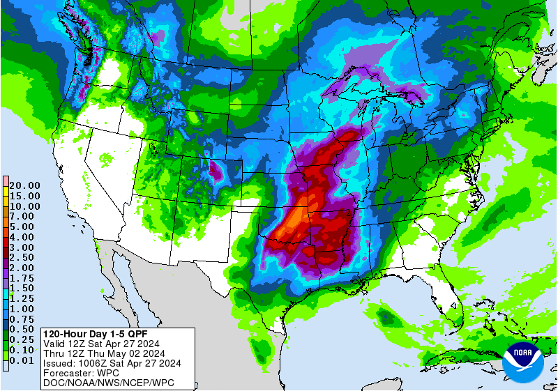
Bad thing is shear is still supposed to relax, and it is in bathtub water.. So you can't let your guard down as whatever this is should be coming through TX in less than 2 days, even though at this time it doesn't look like much more than rain and elevated wind & seas(I was supposed to be fishing King of the Deep tournament out of Matty this weekend too!). Rainfall amounts don't look to be too excessive per the QPF chart, but I don't get the feeling anyone is too confident on forecast..
Comment
-
the model right above your post only has one 'guess' thats even close to Matty. Looks to be like brownsville and further south needs to worry more than POC/Matty areaOriginally posted by TexasBob View PostComment
-
-
In
Sent from my iPhone using TapatalkComment
-
Any update? I guess it won’t be a big deal since none of our resident weather guys seem to be getting too worked up over it. A rain maker wouldn’t be bad for most of Texas thoughComment
-
Wednesday Evening Update from Jeff Lindner with HCFCD.
Four active named storms currently in the Atlantic basin with Joyce having formed in the far north Atlantic this afternoon
95L:
Satellite images suggest that a broad area of surface low pressure has formed today over the south-central Gulf of Mexico and thunderstorms activity has increased somewhat although it remains fairly disorganized. Based on the current data there is a 70% chance that a tropical depression will form in the next 24 hours over the western Gulf of Mexico. This feature is generally moving toward the NW at around 10mph and will be approaching the lower or middle TX coast on Friday. Conditions across the NW Gulf of Mexico will gradually become more favorable for the development of a tropical depression or storm over the next 24-36 hours and it is possible if not likely that the broad surface low will consolidate as it nears the coast on Friday.
Regardless of this system being declared a tropical storm or depression, the impacts along the TX coast will be nearly the same….heavy rainfall and potential flooding.
A Flash Flood Watch has been issued from midnight tonight to 700pm Thursday for all the coastal counties and SE Harris County where rainfall over the last 2-3 days has averaged 3-6 inches with isolated totals of up to 10 inches. Grounds over these areas are saturated and additional rainfall is expected to develop again overnight and impact many of these same areas.
Rainbands from 95L will begin to spread onto the TX coast late Thursday and increase into Thursday night and Friday and continue into Saturday. Widespread rainfall amounts of 2-4 inches will be common mainly south of I-10 tonight-Saturday night with isolated totals of 6-8 inches. North of I-10 rainfall amounts will likely average 1-3 inches with isolated totals of up to 4 inches. There is still some uncertainty with these rainfall numbers and they could change up or down in the next 24-48 hours.
The greatest threat for flooding will be over the areas that have experienced the most rainfall over the last several days or generally across the coastal counties and into SE Harris County and then further inland over the coastal bend and SW TX where rainfall has been plentiful and rivers already running high.
Will maintain winds of 10-20mph inland and 15-25mph along the coast an offshore unless the system becomes stronger than currently expected.
Tides will run about 1.0-1.5 feet above predicted levels along the coast with total water levels of 3.0-3.5 feet above MLLW which is generally below thresholds needed to cause issues along Bolivar, the west end of Galveston and along the west side of Galveston Bay.Comment
-
Looking at the radar on Accuweather I don’t even see rain bands off this Invest 95L, or whatever it’s called.Originally posted by ccbluewater View PostComment
-
.Attached FilesComment
-
-
Looks like we can keep this thread going for awhile. EURO has Isaac hitting Louisiana in 10 days.Comment
-
Yep, tis the season I suppose..Originally posted by JeffK View Post
Euro Ensemble members are a lot more interested in this than they have been. It had been burying this into Central America.
10+ Days out though so a long time to wait and see..

Comment
-
Potential Tropical Development
So the model consensus is... anywhere it
could possibly go
Sent from my iPhone using TapatalkComment
-
right.Originally posted by TexasBob View Post
I do like that only ONE model has it coming here and elevendy million somewhere elseComment

Comment